Census geography: Bridging data from prior years to the 2010 tract boundaries>>
Boundary changes in the 2010 Census
Three kinds of changes in census geography need to be considered in any intercensal bridging system: consolidations, splits, and complex changes. These are illustrated in the following figure for several tracts in the Kansas City metropolis. Consolidation creates no difficulties for analysis (other than the loss of detailed geographic information); in this example data for three tracts in 2000 can simply be combined into a single tract as defined in 2010. A split adds difficulty. In this example, some rationale is needed to allocate data from one tract (053106) into three new tracts formed within it.
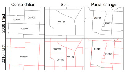
Three types of boundary changes in the Kansas City metropolis from 2000 (in black) to 2010 (in red)
Some more complex changes are shown in the right-hand panel. First, the western and southern boundaries of tract 013401 have been adjusted, which means that some population needs to be exchanged between adjacent tracts. Note that some of these changes appear to be very small, suggesting possibly some technical improvement in the GIS file (and there are many thousands of these around the country). But the section removed from this tracts southwest corner could be more significant. Of course it would require intensive investigation to discover the rationale for this change. In addition, what used to be two tracts to the east of 013301 have been reorganized into three, retaining the outer boundaries of the original two but entirely disregarding the prior boundary between them.
For the period 2000-2010 we have counted the number of tracts with changes of each type. Of the 72,739 tracts with land area in 2010, we classify 50,062 tracts as unchanged in 2010, though about one-third of these (17,898) experienced slight boundary corrections. Of tracts with changes, only a small number of cases (less than 1000) are consolidations. The most common types of change are those where some form of estimation is required. In over 17% of cases a single tract in 2000 was split into more than one tract in 2010, and most of these were the result of 1 to 2 splits. A nearly equal number of 2010 tracts fall into the many to many category, where multiple tracts in 2000 were reconfigured to produce a different set of tracts in 2010.
We illustrate the extent and location of these changes in another figure, which presents an overlay of 2000 and 2010 tract boundaries in the Kansas City metropolis. There were a number of consolidations particularly in central city areas of Kansas City Missouri that were losing population, and a larger number of splits located mainly in outer suburban areas.
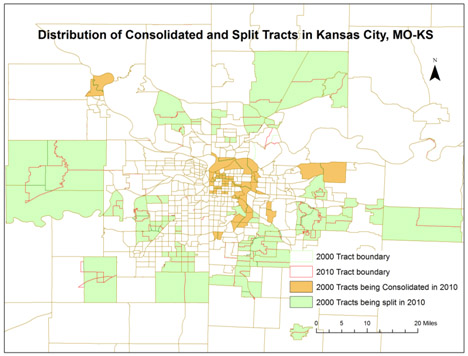
Overlay of tract boundaries in 2000 and 2010 in Kansas City, MO-KS MSA.